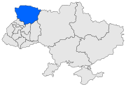
Volhynian Voivodeship (1569–1795)
Voivodeship of the Grand Duchy of Lithuania then of the Kingdom of PolandVolhynian Voivodeship was a unit of administrative division and local government in the Grand Duchy of Lithuania from 1566 until 1569 and of the Polish Crown within the Polish–Lithuanian Commonwealth from the 1569 Union of Lublin until the Third Partition of Poland in 1795. It was part of the Ruthenian lands in the Lesser Poland Province.
Read article
Top Questions
AI generatedMore questions
Nearby Places

Volhynia
Historical region in Central and Eastern Europe

Wołyń Voivodeship (1921–1939)
Former voivodeship of Poland

Ukrainian Catholic Archiepiscopal Exarchate of Lutsk
Ukrainian Catholic missionary jurisdiction in north western Ukraine

Lubart's Castle
14th century castle in Lutsk, Ukraine

Market Square (Lutsk)

Lutsk Orthodox Fellowship of the True Cross
Church in Lutsk, Ukraine

Lesya Ukrainka street, Lutsk

Holy Trinity Orthodox Cathedral, Lutsk
Church in Lutsk, Ukraine


